Whalechaser's Musings

No Matter Where You Go...
There You Are
Make the Best of It

Friday, August 31, 2007

Day 11...The Royal Gorge and White Water Rafting

Now that the domestic chores are behind me, we took off early this morning for Canon City where the train depot for the Royal Gorge is located. We met up with our rafting group and rode up river to the put in place Pinnacle Rock on the Arkansas River.


There were six of us in the raft and the guide. We got hung on a rock early in the trip, but the guide, Dan, was experienced and got us going again without a spill or a dump. Too bad I couldn't take my camera, but the risk of total annihilation was too great. So I will have to settle for pictures of others doing white water rafting through the gorge that I took from the train. (I did the same thing...really!)


We did get sprayed several times, but that's what it's all about! We lunched by the river and then took the Royal Gorge Train through the canyon to the station. It was a great experience and later in the trip we will likely do a trip with higher ratings. This one was mostly rated 2 and 3 with only 2, 4 rated rapids. Later we will do one where the standard ratings are 3 to 4 and a couple of 5's just for the fun of it.

Here is the train getting spruced up before its first run of the day.


Here are some rafters having a ball on the Arkansas River.


The train through the gorge was really fun and the view was like none other.


Rafters making it through some white water


Rafters having made it through some rough stuff doing a high-five with the paddles


Through the gorge, you can see the old WOODEN pipes that were used to transport water from the lakes to the city. Amazing, these pipes were made to fit in the same manner as a barrel.


Across the narrowest section of the gorge is a suspension bridge that one can walk over (assuming you don't have any problems with heights...that would NOT be me!)


On the way back from the train ride, we took a side trip on the Skyline Drive just outside of Canon City. This road is only one lane wide and is one way for its entirety. It felt just like driving on a single driveway; no extra space on either side! It is 800 feet above Canon City.


Belive it or not, we found a walker just about half way through the three mile length of it.

Thursday, August 30, 2007

Day 10...It must be time to...

Today was a day to relax and recuperate from all of the strenuous mountain hiking that we have been doing recently. So we biked for 10 plus miles on the Salida trail system and then did the laundry. Yes, even though this is a vacation, we need to take care of these things before they get out of hand. Fortunately the weather held out until we were finished, then it rained, again.

I have already read two books since the start of this trip and both endings left a little to be desired. So my third choice was by a known author where I know I won't be disappointed with how it ends: The Rainmaker, by John Grisham.

Wednesday, August 29, 2007

Day 9...Anything can happen day

The original plan was that Chuck, Len and Marlene would backpack into the mountains for the next three days; I would play the tourist in this section of Colorado and get more familiar with the 'touristy' locations. But, the weather, which has been off and on rainy for the last three days continues to play with us. Since this backpacking trip would have been quite strenuous, all the 'packers had agreed that they would pass on it this time. Good for me, since I now have company to show me the touristy locations, etc.

For example, here is my modest breakfast. I could have spiced it up a bit with some Road Kill Hot Sauce, but declined


Len ordered the biggest breakfast burrito I have ever seen!


He did a fine job on it too!


The restaurants philosophy on calories...


Back in Salida, with some sunshine so we can dry out the tent and sleeping bags

Tuesday, August 28, 2007

Day 8...Off Road and 4 Wheelin'

We spent the day with our camping buddies and for today we went four wheelin' up a rocky road to an old railroad tunnel near the base of a mountain. There were two trails going off in different directions and we hiked both of them.

The first was The Native Lake Trail which was absolutely spectacular. It was an Intermediate level hike and there were spots that really had me going. Altogether we hikes 5.5 miles on this one.

We had lunch just outside the the old mine then drove up the rock road, to the Midland Railroad Grade Trail. This one is 11,500 feet and is also an intermediate trail. This one was very strenuous for the last 400 feet to the top. But as seems to be the usual case, it is well worth the effort since the views and the "finds" are very special. We hiked about 6.5 miles on this one.

Before we even got to the trails, we stopped to enjoy the vista, Len was deep in thought with his new GPS gadget.


Later we saw some more mountain streams and


...the biggest reddest mushrooms ever!

Here is Chuck, happy in his element

More terrific mountain views

All together now...It is funny how three or four trees will grow so closely together.

Another mountain stream...

Douglass City, a rip-roarin mining town that is now defunct


Here is Chuck after having taken a picture of the remains of one of the cabins of the old populated Douglass City.

Here we are almost at the top; the sign designates the Hagerman Tunnel and its current condition. They were right to tell you to stay out. Anything could fall at any time!


The Top..At Last!

The first wildlife that I have seen here in Colorado. I was expecting big horned sheep, elk, deer, bear or any other big four legged animals. But no...I find a Pika, an animal just a little larger than a chipmunk; also known as a Rock Rabbit or Hay Farmer. They are cute and very industrious. Click the picture and see him on the top of the rock.

Monday, August 27, 2007

Day 7...Fish Hatchery and Blue Diamond Trail

One of the best parts about travelling is finding the best places to eat in each town that we stop in. For Leadville the absolute best place for breakfast is Scott and Stephs. We didn't have to seek this one out though, Len and Marlene already knew about it, we just had to enjoy.


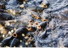
Here is the hatchery and some of the larger trout.


After Breakfast we drove to the fish hatchery and looked at that operation, then we went on the Blue Diamond Trail for a 7 mile hike.

Got some shots of the beautiful scenery. This place is fantastic for gorgeous forests and natural settings

Sunday, August 26, 2007

Day 6...Leaving Salida; Arriving Leadville, Colorado

We checked out of the motel in the morning, after riding for 8 miles on the bike trail that goes through the City of Salida,
had a great breakfast

and cleaned up the van before starting our trip to Leadville, Colorado, alt 10,800 feet.


Leadville is a town that is the highest populated town in the United States. It started out as a mining town.

It has many of these mining cars dispersed throughout the town; currently being used as very large flower pots, cute though.

We had dinner at the Golden Burro...they have another name for it! I had the Fried Chicken and was happy as a clam.


We walked around town after dinner and found the most unusual purple house.


Here we met up with our camping buddies Len and Marlene and got the tents set up before the late afternoon shower. We did squeeze in a walk around the two loops of our campground and the lake before the rain.

Saturday, August 25, 2007

Day 5...THE DUNES

Today was the day we were waiting for. Hiking up to the top of the dunes. Three days of acclimation and now for the big test.
We started out at 8:45, which was a little later than we planned on, but worked out just fine. We took the trail from our camping area rather than driving to the parking area and walking to the middle of the dune. This approach brought us to the far right side and a ranger told us it might be a bit easier to get to the top from that approach.
Here are the pics from that hike. We actually did make it, I for one was shocked and elated to be able to reach the top There were times when each step took all of my concentration and effort. Each step sinking into the sand and the incline sharp enough to deter anyone. I think the height of about 700 feet translates into about a 70 story building, just to give you an idea of the effort involved.
Enjoy the pictures. Also, if you leave or use your email address, I can reply.

Here we are starting the hike with the sun at our backs.

We are almost there, Chuck had gotten way ahead of me and so decided to get a few shots while waiting for me to catch up.

Here we are really close to the top and I saw another couple with their dog just starting out. They look so small!

Ridge lines and tracks in the sand...

We made it!


We left the Dunes this morning and travelled to Salida. A city about an hour northwest of the Dunes. We will meet up with friends tomorrow in Leadville, Colorado. This is a place with an elevation of about 10,000 feet. This is why we needed to acclimate to the height earlier this week.
In Salida we went downtown to the Arkansas river headwaters and found several people testing their kayak skills...it was fun to watch and it also screamed to me how little experience I really have when it comes to kayaking!
Hey I also got new shoes!